
If you were planning on enjoying a spot of hiking on your trip to Tenerife, you’re in luck: this island has no shortage of hiking trails to explore its diverse landscapes, with everything from laurel forests to awe-inspiring beaches and ravines.
This article looks at the best excursions in Tenerife, focusing on the charming trails in the northern region. So, put on your hiking boots and grab your rucksack; it’s time to discover what this incredible island has in store for us.
The best trails of Tenerife North
Tenerife, known for its jaw-dropping scenery and lush vegetation, has a number of hiking routes in Tenerife North to suit all tastes and fitness levels. Whether you’re an experienced hiker or just starting out, the northern region has trails for everyone.
Quick Table: Choose Your Adventure
Short on time? Here is a summary to help you choose your ideal route:
| Route | Level | Highlights |
|---|---|---|
| 1. Path of the Senses | Very Easy 🟢 | Laurel Forest (Great for kids) |
| 2. Las Vueltas de Taganana | Medium 🟡 | History & Ocean Views |
| 3. Chinyero Volcano | Easy 🟢 | Black volcanic landscape & Pines |
| 4. Rambla de Castro | Easy 🟢 | Coast, palm groves & ruins |
| 5. Las Raíces Forest | Easy/Medium 🟡 | Pine forests & fresh air |
| 6. Humboldt Viewpoint | Easy/Cultural 🟢 | Views of the Orotava Valley |
The Senses Trail: Anaga Rural Park
📋 Quick Facts:
- 📍 Start: Cruz del Carmen (Visitor Center).
- ⏱ Duration: 15 min – 45 min (depending on the trail).
- 🟢 Difficulty: Very low (Trail 1 is wheelchair accessible).
- 🌲 Best for: An immersive experience in the Laurel Forest.
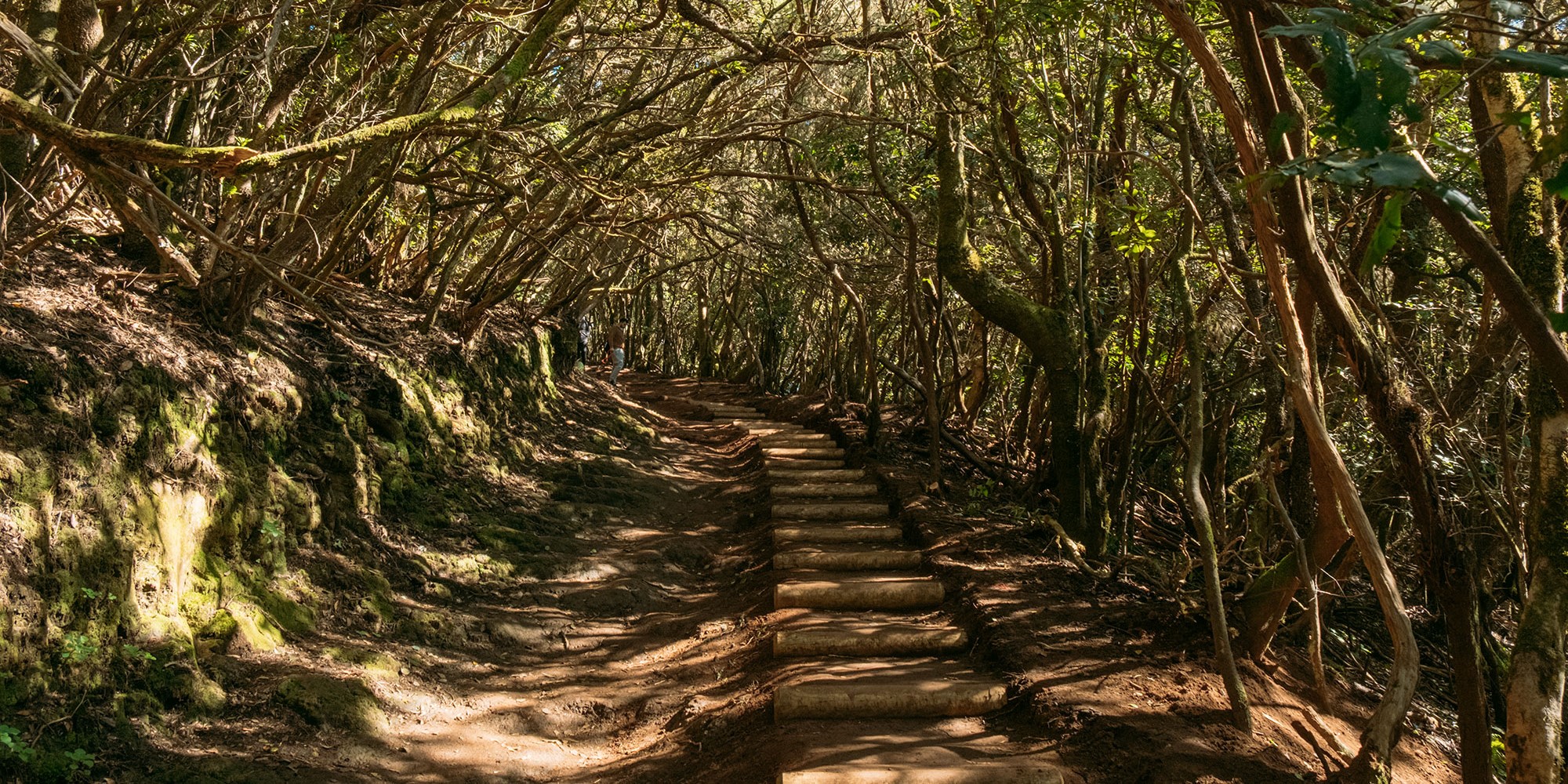
The Path of the Senses (Sendero de los Sentidos), immersed in the Anaga Rural Park in Tenerife, provides an accessible experience for all audiences. Located at Cruz del Carmen, near the Jardina Viewpoint, this trail is ideal for nature lovers and for those looking to explore the island without prior physical preparation.
At the beginning of the trail is the Cruz del Carmen Visitor Center, which has parking and a viewpoint with impressive views of the Anaga Massif, San Cristóbal de La Laguna, and parts of the capital. Historically, part of the Path of the Senses served as a Royal Road (Camino Real) connecting La Laguna with Anaga. The name “Path of the Senses” is appropriate, as information panels along the way stimulate touch, smell, sight, and hearing, immersing visitors in the natural environment.
The trail is divided into three sections, each designed to suit different levels. Trail 1, accessible by wheelchair, offers a brief introduction to the local vegetation. Trail 2, just over half a kilometer long, can be visited in just fifteen minutes. Trail 3, lasting 30 to 45 minutes, presents the most significant change in elevation. Although they differ in length, all three trails maintain a low level of difficulty.
💡 The Sansofé Tip: The parking lot at Cruz del Carmen is small and very popular. We recommend arriving before 10:00 AM or after 3:00 PM to find a spot easily. Also, always bring a light jacket: the humidity of the forest makes the temperature feel lower than on the coast.
Vueltas de Taganana Trail
📋 Quick Facts:
- 📍 Start: Anaga Forestry House (Casa Forestal).
- 🏁 End: Village of Taganana.
- ⏱ Duration: 2h – 3h (Descent).
- 🟡 Difficulty: Medium (Continuous descent and damp ground).
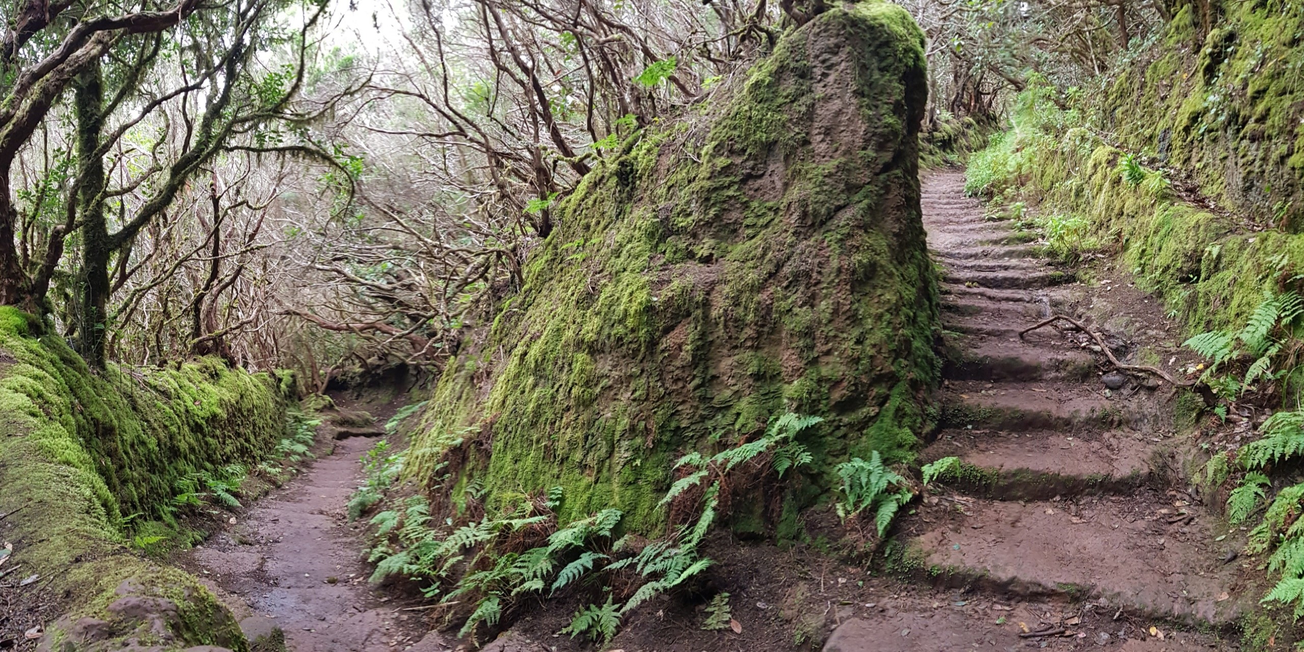
Located in the stunning Anaga Massif, the Las Vueltas de Taganana Trail unfolds in a zigzag from a historic forestry house, descending from 870 meters above sea level. This path, loaded with history and natural charm, is protected as a Rural Park and UNESCO Biosphere Reserve, standing out for its humid and lush landscape, thanks to the trade winds.
Built in 1506 to link Taganana with La Laguna, the route reveals vestiges of the past, such as old watering troughs and a cave carved into the rock. Along the route, the varied flora captures the essence of the environment, from mosses and ferns in the shade to the viñátigo tree, whose leaves turn reddish hues.
This trail goes beyond a simple hike; it is an immersion in the nature and history of Anaga.
💡 The Sansofé Tip: Watch out for logistics! This is a linear route (usually done downwards). If you leave your car up at the Forestry House, once you arrive in Taganana you will need to take a bus (guagua) or taxi to go back up and get it, unless you have legs of steel to do the reverse path uphill. Also, the ground is often wet: wear shoes with good grip to avoid slipping on the “turns” (vueltas).
Chinyero Trail
📋 Quick Facts:
- 📍 Start: Km 15 of the TF-38 road.
- 📏 Distance: 6.6 km (Circular Route PR-TF-43).
- ⏱ Duration: Approx. 2 hours.
- 🟢 Difficulty: Easy (Flat terrain, ideal for families).
- 🌋 Best for: The contrast of green pine trees against black lava.
The Chinyero Trail is one of the most fascinating hiking routes in Tenerife, as you can discover the geological richness of the island. In addition to its geological value, it holds a fascinating history, since the Chinyero Volcano was the last to erupt in Tenerife in 1909. For 10 days, it spewed lava, threatening towns like Santiago del Teide and Guía de Isora.
The eruption left an indelible mark on the population of the time, who, in fear, carried out processions to the Calvary in Las Manchas. Miraculously, the lava stopped, creating a deep-rooted belief. Annually, a procession is held in memory of those days of panic.
The route through the Chinyero Volcano (PR-TF-43), of only 6.6 km, is completely accessible to anyone. You will be able to see the Canarian pines and the impressive contrast with the volcanic soil. From the trail, you will also have enviable views of Mount Teide and the Pico Viejo Volcano.
To start this adventure, you just have to head to kilometer 15 of the TF-38 and enter the Chinyero Special Natural Reserve.
💡 The Sansofé Tip: Although the route is simple and without steep slopes, you are walking on volcanic lava at altitude. The sun hits hard here and the black ground radiates heat. Don’t forget a hat, sunscreen, and water, even if you go in winter. And bring a charged camera! The color contrast here is unique in the world.

La Rambla de Castro Trail
📋 Quick Facts:
- 📍 Start: Los Roques Beach (Los Realejos).
- 🏁 End: San Pedro Viewpoint (or return to start).
- 📏 Distance: 9 km approx (Round trip).
- 🟢 Difficulty: Low/Medium (Coastal path with some slopes).
- 📸 Best for: The Gordejuela ruins and the endless palm grove.
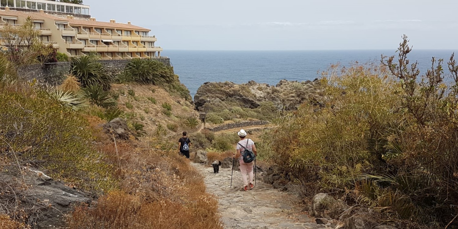
The Rambla de Castro Route, situated in Los Realejos, is a fascinating journey through Canarian history and nature. The Rambla de Castro, cataloged as a Protected Landscape, covers 46 hectares of an exceptional natural environment, highlighting its significant Palm Grove. Starting at Los Roques Beach, the route features unique landscapes, such as black sand, rock formations, and wild waves, ideal for photography lovers.
In addition to its beauty, the route stands out for the presence of various specimens of dragon trees and protected species of flora and fauna. We recommend following the route in the direction from Los Roques Beach to the San Pedro Viewpoint, enjoying approximately 9 km in a day (round trip). During the journey, historical buildings are found such as the Gordejuela Water Elevator, a hydraulic pumping station built in 1903, and the San Fernando Fort, erected in the 18th century as a defense against pirates. The tour ends next to La Casona de los Castros, a 16th-century estate currently in the process of restoration, as it plans to become a visitor center.
💡 The Sansofé Tip: Get your camera (or phone) ready because you are going to pass by one of the most “Instagrammable” places on the island: the ruins of the Gordejuela Water Elevator. It looks like an abandoned mansion hanging from the cliff, but it was an old water pumping station. Upon reaching the San Pedro Viewpoint, take the opportunity to have a drink at the restaurant with views before starting the way back.
Las Raíces Circular Trail
📋 Quick Facts:
- 📍 Start/End: Las Raíces Recreational Area (Road TF-24, Km 10).
- 📏 Distance: 5.3 km (Circular).
- ⏱ Duration: 1h 30m – 2h.
- 🟢 Difficulty: Low (Trail PR-TF 25.1).
- 🌲 Best for: The scent of pine and views of the Güímar Valley.
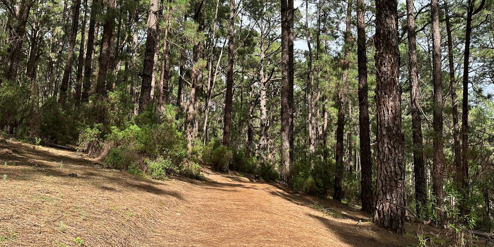
The circular route that starts from the Las Raíces Recreational Area towards Montaña Chica is a journey that runs through a lush pine forest. As you delve into this pine forest, magnificent panoramic views of the Güímar Valley unfold, with the prominent Montaña del Socorro, also known as Montaña Grande.
After crossing the Maravedís Ravine, you ascend some wooden stairs to the area known as Benijo, to finally return to the Las Raíces Recreational Area, the starting and ending point of the route.
The trail begins at kilometer 10 of the TF-24 road, near a restaurant at the fork where the Los Ovejeros Forest Track begins. With a low difficulty and a length of 5.3 km, the trail follows approved and signposted paths such as the PR-TF-25.1, and connects with other routes such as PR-TF-25, Circular de las Barreras, SL-TF-301, and Lomo del Centeno, SL-TF-299.
💡 The Sansofé Tip: You are in the heart of the Monte de la Esperanza. Here the temperature usually drops several degrees compared to the coast and it is common to find fog (the famous “donkey’s belly” or panza de burro) which gives a mystical touch to the forest. Always bring a sweatshirt or windbreaker. When you finish, take advantage of the tables in the Recreational Area to eat a sandwich surrounded by nature.
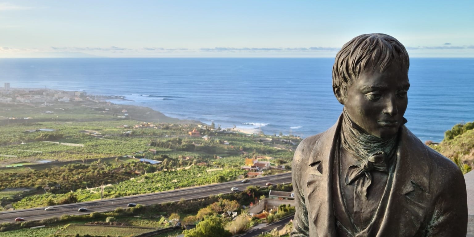
Humboldt Viewpoint Trail
📋 Quick Facts:
- 📍 Location: Cuesta de la Villa (La Orotava).
- 👁️ Best for: The panoramic view of the Valley and Teide.
- 🧠 History: Follow in the footsteps of naturalist Alexander von Humboldt.
- 🚶 Type: Cultural / Scenic Route.
The Humboldt Viewpoint pays tribute to the famous German scientist Alexander von Humboldt. This trail, which starts from the viewpoint that bears his name, allows visitors to follow in Humboldt’s footsteps and immerse themselves in the natural beauty of the island.
The viewpoint itself provides impressive views of the Orotava Valley, with the imposing Teide as a backdrop. The lush green valley, contrasted with the majesty of Teide, offers a landscape that captured Humboldt’s admiration during his visit.
The trail continues along the route that Humboldt may have taken on his ascent to Teide. Hikers can explore the geobotanical diversity of the island, from coastal zones to higher altitudes. The path winds through forests, rocky terrain, and emblematic places that Humboldt may have also experienced. The journey culminates at the viewpoint, giving visitors the opportunity to reflect on Humboldt’s observations and discoveries.
💡 The Sansofé Tip: Humboldt said that this valley was the most beautiful landscape his eyes had ever seen. To verify this, try to visit the viewpoint at sunset, when the golden light bathes the valley and Teide turns violet. If you want to keep walking up into the forest, from here you are just a few minutes drive from the La Caldera (Aguamansa) recreational area, where the route goes deep into the wild nature.
Come discover these trails in Tenerife North
Tenerife’s diverse landscapes, from lush forests to volcanic summits, make the island a hiker’s paradise. Whether you go for the northern trails with their laurel forests or the southern charm of Montaña Roja; each and every hike is a one-of-a-kind experience.
Discover Tenerife North with Sansofé. Choose one of the 10 houses within our organic avocado farm in La Matanza de Acentejo, a charming village in the north of the island. Sansofé isn’t just a place stay; it’s a unique experience that strikes the perfect balance between the tranquillity of nature and modern comfort.

SEA VIEW, HEATED POOL, Heating, PRIVATE GARDEN AND TERRACE, Free Wifi (10)
From 95.00€ per night

House, SEA VIEW, HEATED POOL, Heating, Sun set and rise terrace, Free wi fi(9)
From 95.00€ per night

1 Bedroom , SEA VIEW, HEATED POOL, Heating, free Wifi, big terrace (1)
From 85.00€ per night

One bedroom, SEA VIEW, HEATED POOL, Heating, Free wif, Big terrace, (2)
From 85.00€ per night
Where to stay to explore the North?
The north of Tenerife is a hiker’s paradise, but the roads are winding and you don’t want to spend the whole day driving. The ideal solution is a strategic ‘base camp’.
At Sansofé Stay, we are located in La Matanza de Acentejo, right in the middle between the Anaga forests and the La Orotava/Teide routes. Our eco-friendly estates offer the perfect rest (and incredible sunset views) after a day of hiking.